|
|
Garmin Cartography
Garmin Cartography
Displaying 1 to 6 (of 6 products)
| Model No. |
Manufacturer No. |
Product Image |
Product Name |
Price |
| 322-010C070300 | 010C070300 |  | Bluechart&Reg; G2 Vision Card, South Maine
Plug a BlueChart g2 Vision card into your compatible device's SDTM card slot and tremendously expand its mapping capabilities. High-resolution satellite imagery enhances chart depictions for superior situational awareness so you can navigate with a clear moving-map representation of your boat's position. It's the most realistic mapping display Garmin has ever offered in a chartplotter. High resolution satellite imagery, when overlaid on the chart, provides the mariner with unparalleled situational awareness
Aerial reference photography provides "real world" photos of ports, harbors, marinas, waterways, navigation landmarks and other points of interest, offering the mariner another powerful tool for navigating unfamiliar waters
Mariner's Eye View perspective provides a bird's eye view from behind the boat showing the chart information for a quick, reliable and easy position fix
Fish Eye View 3D perspective provides an underwater view that visually represents the sea floor according to the chart's information
Auto Guidance technology searches chart data to suggest the best passage to a destination
Fishing charts allow the mariner to hide navigation data from the SD card while leaving the bottom contours and depth soundings for their next fishing adventure
Includes tides, currents, marine services, coastal roads and points of interest
Detailed BlueChart g2 maps are includ500, 600, 700, 4000, 5000, 6000, 7000 | $269.61
... more info

|
| 322-010C070400 | 010C070400 |  | Bluechart&Reg; G2 Vision Card, Cape Cod
Plug a BlueChart g2 Vision card into your compatible device's SDTM card slot and tremendously expand its mapping capabilities. High-resolution satellite imagery enhances chart depictions for superior situational awareness so you can navigate with a clear moving-map representation of your boat's position. It's the most realistic mapping display Garmin has ever offered in a chartplotter. High resolution satellite imagery, when overlaid on the chart, provides the mariner with unparalleled situational awareness
Aerial reference photography provides "real world" photos of ports, harbors, marinas, waterways, navigation landmarks and other points of interest, offering the mariner another powerful tool for navigating unfamiliar waters
Mariner's Eye View perspective provides a bird's eye view from behind the boat showing the chart information for a quick, reliable and easy position fix
Fish Eye View 3D perspective provides an underwater view that visually represents the sea floor according to the chart's information
Auto Guidance technology searches chart data to suggest the best passage to a destination
Fishing charts allow the mariner to hide navigation data from the SD card while leaving the bottom contours and depth soundings for their next fishing adventure
Includes tides, currents, marine services, coastal roads and points of interest
Detailed BlueChart g2 maps are includ500, 600, 700, 4000, 5000, 6000, 7000 | $269.61
... more info
|
| 322-010C070500 | 010C070500 | 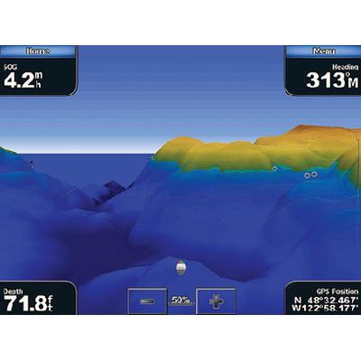 | Bluechart&Reg; G2 Vision Card, New York
Plug a BlueChart g2 Vision card into your compatible device's SDTM card slot and tremendously expand its mapping capabilities. High-resolution satellite imagery enhances chart depictions for superior situational awareness so you can navigate with a clear moving-map representation of your boat's position. It's the most realistic mapping display Garmin has ever offered in a chartplotter. High resolution satellite imagery, when overlaid on the chart, provides the mariner with unparalleled situational awareness
Aerial reference photography provides "real world" photos of ports, harbors, marinas, waterways, navigation landmarks and other points of interest, offering the mariner another powerful tool for navigating unfamiliar waters
Mariner's Eye View perspective provides a bird's eye view from behind the boat showing the chart information for a quick, reliable and easy position fix
Fish Eye View 3D perspective provides an underwater view that visually represents the sea floor according to the chart's information
Auto Guidance technology searches chart data to suggest the best passage to a destination
Fishing charts allow the mariner to hide navigation data from the SD card while leaving the bottom contours and depth soundings for their next fishing adventure
Includes tides, currents, marine services, coastal roads and points of interest
Detailed BlueChart g2 maps are includ500, 600, 700, 4000, 5000, 6000, 7000 | $269.61
... more info
|
| 322-010C071100 | 010C071100 |  | Bluechart&Reg; G2 Vision Card, SE Florida
Plug a BlueChart g2 Vision card into your compatible device's SDTM card slot and tremendously expand its mapping capabilities. High-resolution satellite imagery enhances chart depictions for superior situational awareness so you can navigate with a clear moving-map representation of your boat's position. It's the most realistic mapping display Garmin has ever offered in a chartplotter. High resolution satellite imagery, when overlaid on the chart, provides the mariner with unparalleled situational awareness
Aerial reference photography provides "real world" photos of ports, harbors, marinas, waterways, navigation landmarks and other points of interest, offering the mariner another powerful tool for navigating unfamiliar waters
Mariner's Eye View perspective provides a bird's eye view from behind the boat showing the chart information for a quick, reliable and easy position fix
Fish Eye View 3D perspective provides an underwater view that visually represents the sea floor according to the chart's information
Auto Guidance technology searches chart data to suggest the best passage to a destination
Fishing charts allow the mariner to hide navigation data from the SD card while leaving the bottom contours and depth soundings for their next fishing adventure
Includes tides, currents, marine services, coastal roads and points of interest
Detailed BlueChart g2 maps are includ500, 600, 700, 4000, 5000, 6000, 7000 | $269.61

|
| 322-010C071200 | 010C071200 | 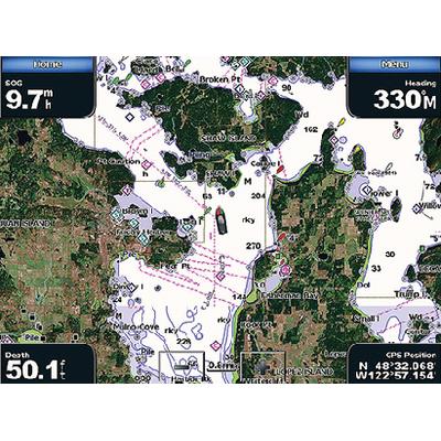 | Bluechart&Reg; G2 Vision Card, Florida
Plug a BlueChart g2 Vision card into your compatible device's SDTM card slot and tremendously expand its mapping capabilities. High-resolution satellite imagery enhances chart depictions for superior situational awareness so you can navigate with a clear moving-map representation of your boat's position. It's the most realistic mapping display Garmin has ever offered in a chartplotter. High resolution satellite imagery, when overlaid on the chart, provides the mariner with unparalleled situational awareness
Aerial reference photography provides "real world" photos of ports, harbors, marinas, waterways, navigation landmarks and other points of interest, offering the mariner another powerful tool for navigating unfamiliar waters
Mariner's Eye View perspective provides a bird's eye view from behind the boat showing the chart information for a quick, reliable and easy position fix
Fish Eye View 3D perspective provides an underwater view that visually represents the sea floor according to the chart's information
Auto Guidance technology searches chart data to suggest the best passage to a destination
Fishing charts allow the mariner to hide navigation data from the SD card while leaving the bottom contours and depth soundings for their next fishing adventure
Includes tides, currents, marine services, coastal roads and points of interest
Detailed BlueChart g2 maps are includ500, 600, 700, 4000, 5000, 6000, 7000 | $269.61
|
| 322-010C074200 | 010C074200 | 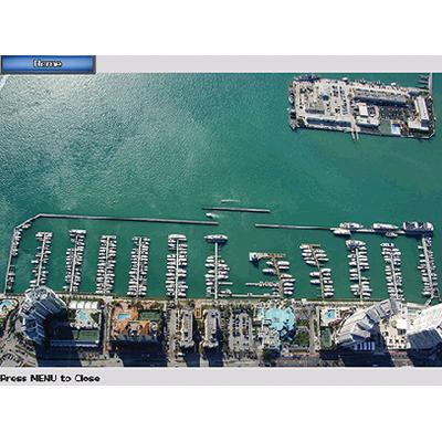 | Bluechart&Reg; G2 Vision Card, Jacksonville-Bahamas
Plug a BlueChart g2 Vision card into your compatible device's SDTM card slot and tremendously expand its mapping capabilities. High-resolution satellite imagery enhances chart depictions for superior situational awareness so you can navigate with a clear moving-map representation of your boat's position. It's the most realistic mapping display Garmin has ever offered in a chartplotter. High resolution satellite imagery, when overlaid on the chart, provides the mariner with unparalleled situational awareness
Aerial reference photography provides "real world" photos of ports, harbors, marinas, waterways, navigation landmarks and other points of interest, offering the mariner another powerful tool for navigating unfamiliar waters
Mariner's Eye View perspective provides a bird's eye view from behind the boat showing the chart information for a quick, reliable and easy position fix
Fish Eye View 3D perspective provides an underwater view that visually represents the sea floor according to the chart's information
Auto Guidance technology searches chart data to suggest the best passage to a destination
Fishing charts allow the mariner to hide navigation data from the SD card while leaving the bottom contours and depth soundings for their next fishing adventure
Includes tides, currents, marine services, coastal roads and points of interest
Detailed BlueChart g2 maps are includ500, 600, 700, 4000, 5000, 6000, 7000 | $359.49
|
|